
Deer Creek Habitat Enhancement Project Underway
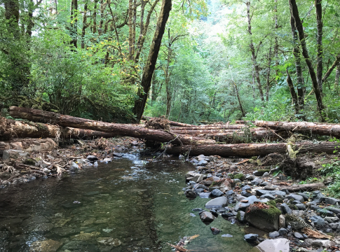
EWEB, McKenzie Watershed Council and the Willamette National Forest are collaboratively working on the project, which involves relocating a portion of 115 kV transmission line.
In the late 1950s and early 1960s when EWEB's Carmen-Smith Hydroelectric Project was originally built 70 miles east of Eugene on the upper McKenzie River, the area was isolated and much of the surrounding land was undeveloped national forest with limited access. Bringing power from the generator to Eugene homes and businesses required construction of an 18-mile transmission line to Cougar Reservoir, where it connects to the Bonneville Power Administration's system.
That transmission system, still in use today, runs primarily along hillsides and ridges. But in the lower Deer Creek valley, the high voltage powerlines intersect approximately three quarters of a mile of floodplain which, under historically natural conditions, was prime habitat for fish and other wildlife.
Deer Creek is the largest tributary to the McKenzie River and journeys approximately eight miles from its headwaters to its confluence with the McKenzie, currently Eugene's sole source of drinking water. Past land management practices, such as riparian logging, had impaired the watershed and contributed to poor habitat conditions in lower Deer Creek.
"Unfortunately, when the transmission line was routed through the Deer Creek floodplain around 60 years ago, it contributed to degradation of the riparian zone and habitat," says EWEB Generation Manager Mike McCann. "By Federal law, EWEB is required to manage vegetation below the transmission lines, so periodically we have to go in and cut all of the willows and alder and other species that provide shade to the stream, further impacting habitat."
Several years ago, the U.S. Forest Service and the McKenzie Watershed Council partnered to implement a restoration project on the lower portion of Deer Creek. Constraining berms were removed, and large wood was added to create deep pools for fish cover, slower water for resting, and sorted gravels for spawning beds. Initial results were positive, and during 2017, McKenzie Watershed Council reported that spring Chinook Salmon were observed spawning in Deer Creek for the first time since the early 90s.
But the restoration project was limited by EWEB's transmission lines. "It wasn't as effective as we would have liked," says EWEB Drinking Water Source Protection Supervisor Karl Morgenstern. "The powerlines wouldn't let us restore the greater floodplain and you really need to have the scale to make this stuff work."
Then, in the early 2000s, when EWEB began the relicensing process for Carmen-Smith, the Forest Service requested the transmission lines be moved from the Deer Creek riparian zone, if possible.
"That's when EWEB first made the commitment to move the lines to the adjacent hillside," says Mike McCann. "Moving the transmission lines is going to let us open that whole floodplain up for restoration."
This summer, land was cleared for the new hillside transmission corridor. Trees that were removed will be used in Phase 2 of the Deer Creek restoration project to create additional habitat for threatened bull trout and spring Chinook salmon, as well as rainbow and cutthroat trout and beaver.
In addition to restoring and enhancing habitat for native fish and wildlife, the Deer Creek project is key to EWEB's drinking water source protection and climate resiliency work.
"One of the things that came out of this project was a strategy for the future given what precipitation patterns and snowpack have been recently," says Karl Morgenstern. "It makes sense for us to do work in the watershed that keeps as much water on the landscape as possible."
Floodplain restoration helps spread water across the landscape, allowing it to soak in and release later in the summer.
Transmission line relocation is scheduled to begin mid-2021 and will be performed by EWEB electric crews. First the new towers will be installed and the transmission line rerouted, allowing EWEB to remove the existing structures. Once the transmission lines are removed, the floodplain restoration work will continue in the Deer Creek floodplain.
Photo Credit: McKenzie Watershed Council